Thursday, July 31, 2025

Critical Hurricane Forecast Tool To Stay Active After All

Visible satellite view of Hurricane Milton, which
grew explosively in the Gulf of Mexico last year.
At the last minute, the U.S. Defense Department
reversed a decision that would have crippled
nighttime monitoring of developing hurricanes. 
In a rare, wise move from the U.S. Defense Department. they've reversed a recent decision to end satellite monitoring that is crucial to forecasting hurricanes and other dangerous weather. 

That move in June to end the microwave satellite monitoring technology created outcry among meteorologists because they said ending the monitoring would hamstring hurricane forecasting, just as the tropical storm season was getting under way.

Apparently, the pressure from hurricane forecasters and others worked. 

Per the Washington Post:

"....officials at the National Oceanic and Atmospheric Administration said Tuesday that they now expect 'no interruption' in the data their meteorologists received through what is known as the Defense Meteorological Satellite Program, which includes microwave-based observations that reveal storm activity even through the cover of darkness."

The Defense Department was vague about the reasons behind the original decision to shut down the satellite monitoring, hinting at security concerns or a need to replace equipment. 

WaPo continues: 

 "'But after feedback from government partners, officials found a way to meeting modernization goals while keeping the data flowing until the sensor fails or the program formally ends in September, 2026,' a Navy spokesperson said in an email."

The reference to September, 2026 stems from the U.S. Space Force plans to replacing existing satellites with new ones. The first began operating in April but doesn't appear ready yet to do the microwave based observations, at least for storm forecasting. Another satellite should begin running in 2027.

Meteorologists were relieved at the late breaking news. 

 "Some good news for a change! We will keep a critical source of microwave satellite data going for at least another year, or until the satellites, which are already operating 15 year past their expected lifetime, fail," said Dr. Jeff Masters on Bluesky.

There's plenty of satellite data out there to monitor hurricanes during the day. A visual assessment of the clouds swirling around a growing hurricane can offer some of the clues as to whether the storm is strengthening and by how much and where the danger is heading.

The microwave data that almost went away is crucial to head off what hurricane forecasters call "sunrise surprises."

Under the cover of darkness, hurricanes sometimes explosively strengthen, catching people off guard who were expecting a relatively weak hurricane and instead facing a monster, Climate change seems to have increased the frequency of these exploding hurricanes. 

The microwave data allows meteorologists to catch these strengthening trends early, allowing them to quickly adjust forecasts and warn people in nearby coastal areas. 

"The last-minute move averts a crisis for forecasters who rely on the data to predict dangerous and potentially deadly episodes of rapid intensification and their computer models that use data from these microwave imagers to predict the movement and intensity of hurricanes," Michael Lowry, a former National Hurricane Center scientist, wrote on Substack

 We are just getting into the heart of hurricane season.  While no hurricane threats are looming now, it's inevitable that we'll need to carefully watch the Atlantic for these dangerous storms late this month and on into September and October.  

Thursday Morning Vermont Update: Cool, Rain South, Big Time Dry North

This morning's radar, shown at around 7:30 a.m. makes it
look like a lot of rain is falling. But most of it
in central and northern Vermont is evaporating
before it hits the ground, and that state of
affairs should continue all day. The yellow and
dark green in southern Vermont is rain steadily
falling and that should continue all day as well.
 If you looked at weather radar this morning, it seems like it's a really rainy Thursday in Vermont. It's not. 

Sure, a soggy weather system is approaching, but it will pass through our south. Very dry air is streaming in from Canada. 

That dry air is evaporating most of the rain that was trying to fall in central and northern Vermont.

The result will be a cloudy, cool day north, and a rainy day south. 

Not all the rain was evaporating north. Narrow ares of sprinkles were  making it to the ground, which is a bit of a surprise. 

So practically anyone in Vermont might see at least some raindrops here and there today. 

The only substantial rain, though, will hit along and south of Route 4. It looks like there will be a sharp gradient between light rain and heavier stuff. 

Near Rutland and White River Junction, the National Weather Service was calling for only a tenth of an inch of rain or so. (Though morning radar images suggested they might get a little more than that. 

Drive less than an hour or so south down Interstate 91 or Route 7 from Route 4, and soon you could really hit some soakers as you approach Bennington or Brattleboro. Places near the Massachusetts border, especially high elevations like Wilmington, Readsboro and Marlboro, could see up to an inch of rain.

Although we could have used a soaking rain, Vermont is lucky this storm is not going right over us. Those in its direct path - the Mid Atlantic States and areas as far north as Connecticut, are under flood watches today. 

New Jersey, Maryland and eastern Pennsylvania - areas that have already dealt with a lot of flash flooding this summer -  are particularly in trouble today.     

We're talking inches of rain in many of those spots, Some pinpoint areas could see as much as five or six or even more inches of rain, which would cause catastrophic flooding in a highly populated part of the nation.

I guess our national Summer of Floods is continuing. Thankfully not here in Vermont, at least for the time being.

DRY VERMONT WEEKEND

Here in Vermont, after today, we're still expecting the longest dry spell since last September.  We also have an excellent chance of breaking the streak of 32 consecutive weekends with at least a little precipitation  - at least as measured in Burlington.   

National Weather Service rain forecast has nothing in
central and northern Vermont to near an inch near
the Massachusetts border. 

According to one chart from the National Weather Service,  the percent chance of rain this weekend in Burlington gets no higher than 2 percent.  

Those are pretty damn good odds of dry weather. (Though the way this year is going, I almost wouldn't be surprised if it rains from a clear blue sky).

The annoying humidity we've had for at least a week  has been finally be flushed out, too, and it's not coming back for several days at least. 

Which means we have a Chamber of Commerce weather weekend coming up. Lingering clouds in southern Vermont should start to clear Friday. Elsewhere, it's sunshine Friday, Saturday and Sunday. 

I'd scheduled the hike and other physical activity on Friday and maybe Saturday as those days will be cooler.  Highs should be in the 70s both days, with a few low 80s Saturday in the warmer valleys. 

Then do the beach and boat day Sunday, as highs get right up there into the 80s. Despite Sunday's warmth, the humidity should stay low, which will make the days all the more pleasant. 

Low humidity also means temperatures tend to fall off quickly after sunset.  Saturday morning should be the coolest, with sunrise temporaries in the 40s for most of us. Warmer spots in the Champlain Valley would be in the low 50s. The coldest hollows of the Northeast Kingdom and New York's Adirondacks. could see some upper 30s.

The only negative I see in the weekend forecast is some wildfire smoke from Canada. It won't be as thick as it was last Saturday, which brought us some of the worst air pollution on record in Vermont. This time, the smoke might create some light haze, with air quality being so-so, and not particularly dangerous. We hope. 

NEXT RAIN?

Strong high pressure over northern New England and Quebec will be in no hurry to leave. That will keep us warm, with relatively low humidity until about midweek. 

There's mixed signals for the prospects for rain in the middle or end of next week. Some models keep high pressure strong over Quebec and just off the New England coast, which would deflect showers and thunderstorms away from us. 

Other models allow moisture to come up from the Mid-Atlantic states, which would allow a fair number of showers and thunderstorms to blossom toward Wednesday or Thursday. 

Either way, it doesn't look like any kind of real soaker. But that's a week away. Things could change. 

There are signs that the dry high pressure could eventually go offshore and merge with the famous summertime Bermuda High, which opens up a chance at another hot spell beginning in about a week. We're not sure yet, but the long range forecasts so far are leaning that way. 

Wednesday, July 30, 2025

Long Vermont Dry Spell Has Begun. At Least North And Central

A little dew on this flower in my St. Albans, Vermont
gardens this morning. But a generally dry forecast
means I will be watering my gardens more than I
have been so far this summer.  
 How dry we will be. With asterisks.

The gradual trend toward less rain in Vermont will really intensity starting, well, on Monday in some places, and by Friday at the latest in others. 

It sounds complicated but it's not, really.

The main cold front toward our long talked about cool down is coming through today, but I'm really not impressed by the action we'll see along it.  

Let's get into it:

TODAY

It's humid out there, still. And a cold front is at our doorstep. That would seem to be a recipe for a lot of rain and thunderstorms. However, there's dry air aloft, plus the push of cooler air will lag behind the actual cold front.

That leaves with us with only a chance of scattered thunderstorms across the state. At this point, it looks like less than half of us in the northern half of the state will see those showers and storms. In southern Vermont, there will just be isolated storms. 

Some of those few storms this afternoon and evening could still be pretty strong. The dry air aloft can get entrained in some of the storms. When that happens, you can get strong bursts of winds from these storms. 

So, NOAA's Storm Prediction Center gives the southeastern two thirds of Vermont a marginal risk of severe storms. That's the lowest of five risk levels. That means maybe one or two places might have wind strong enough to damage trees or power lines, 

I would say maybe only 30 percent of us will get a nice downpour out of these storms. The rest will of us will see anything from nothing to perhaps a mere tenth of an inch of rain. So no biggie.

Since the cooler air will be lagging, today will end up being one more very warm day. Highs in the 80s north, with some low 90s in warmer southern valleys. 

THURSDAY

Boy, you'll notice the change in the air tomorrow. 

The cold front will have gone through Vermont, meaning all of us will face cool weather for a big change. Most of us will see highs only in the 70 to 75 degree range. A few places will stay in the 60s, especially since clouds will help keep temperatures down. 

That cold front still looks like it will stall temporarily in southern New England, A wet little storm will ride along the front, but there remains debate as to how far north the rain with it will come. 

Southern New England looks like it's in for a good drenching with one to as much as three inches of rain anticipated. 

The rain will probably work north into Vermont, but how far and how much is still anybody's guess. 

Meteorologists are anticipating a sharp south to north boundary between heavy rain and practically nothing.

 If I have to take a shot at it, I'd say Bennington and Windham counties in the far south could see a good half inch of rain out of this.  There could be over an inch - maybe - near the Massachusetts border if things turn out just right. 

Light rain could make it as far north as central Vermont, but it will be battling dry air (and a little wildfire smoke) blowing in from the north.  We'll let you know if the forecast changes

In any event, this sets us up for a real dry period, especially in central Vermont. 

DRY ERA

Central Vermont has missed out on the rain lately more than the far north and far south has or will. It also looks like we'll have little or no rain anywhere in Vermont starting Friday.  

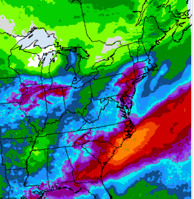
Rainfall prediction map for the next seven days.
The light green in northern Vermont depicts just a tenth
of an inch or less. Southern Vermont could get
a half inch or more, but all of that would
come between now and Thursday night. 

Sunny skies and low humidity are in the cards Friday through Monday at least. 

The relatively cool temperatures of Friday and Saturday will recover to slightly above normal temperatures again Sunday and continue all of next week. (Highs in the 80s)

All that dry weather means many of us will be watering our gardens in some cases for the first time since last summer, considering how wet our spring and early summer was. 

The humidity will start to creep up later next week, which opens the door for spot showers and storms starting maybe the middle of next week.

 But at this point, I don't see any widespread drenchers for quite a long time.

This isn't necessarily the start of a drought, but we will have to start being careful with outdoor fires starting this weekend.  The forest fire danger will start to go up.   

Tuesday, July 29, 2025

Wicked Winds In The Upper Midwest As Wild Thunderstorms Sweep Through

Ominous thunderstorms bear down on the Lewis and
Clark Marina in Yankton, South Dakota Monday
evening in this web cam grab. Violent storms
caused a lot of damage in parts of South Dakota,
Iowa and Minnesota Monday and Monday night.'

The expected big storms - a likely derecho - in the Upper Midwest developed, spreading hurricane-force gusts in parts of South Dakota and Iowa. 

Damage reports are just started coming in, so we don't know the extent of it. But I'm sure there are structures with roof damage, houses with trees into them, and widespread power outages.

A derecho is officially defined as a batch of intense thunderstorms that spread frequent gusts of 58 mph or more, causing damage along a path at least 240 miles long. 

This just happened, so I don't know whether this will be officially defined as a derecho. But it probably will be. Reports of damage and gusts of 60 mph or more were reported between Sioux Falls, South Dakota and at least Davenport, Iowa, and those two cities are about 340 miles apart as the crow flies.

NOAA's Storm Prediction Center will make a final determination as to whether last night's weather meets the derecho criteria.   

The complex of storms created some pretty incredible winds in the eastern half of South Dakota and through Iowa and parts of southern Minnesota.

Wind reports include 99 mph and 92 mph northeast of Sioux City, Iowa; 92 mph in Spencer, Iowa, 90 mph in Janesville, Iowa and 87 mph in Irene, South Dakota. 

Cedar Rapids, Iowa, had gusts to 83 mph. The city was ground zero for arguably the nation's worst derecho on record back in 2020 when wind gusts in Cedar Rapids reached an incredible 140 mph. Still, last night's storm had to be disheartening for a community trying to regrow its tree canopy from the storm five years ago.

Campers, some of them occupied, were blown over in north central Iowa, near the Buddy Holly Crash site.  At least 27,000 Iowans were without power last night.

In South Dakota, tree damage was widespread through much of the eastern part of the sate. A 200-foot tall cell tower collapsed in the town of Hudson.  The tower had carried signals for Verizon, AT&T, and T-Mobile. Companies were working on a temporary fix to return service to the area, according to the Sioux Falls Argus Leader. 

A second clump of storms that was part of the same system produced storms further north in Minnesota and Wisconsin. A storm gust of 76 mph was reported in Rochester, Minnesota

Although there won't be anything as widespread as last night, severe storms are still a good bet in a broad zone from Montana through parts of Wyoming, South Dakota, pretty much all of Nebraska and western Iowa through this evening. 

Video:

Before the likely derecho coalesced, a tornado formed in southern South Dakota. A lightning strike associated with the same storm resulting in this video of the fire and the tornado simultaneously. Click on this link to view, or if you see the image below, click on that. 


One More Hot Day, But The Big Vermont (Temporary) Cool Down Is Just Starting

Our outdoor living summer living space in St. Albans,
Vermont. It looks like the weather will be conducive
to enjoying it most of the time for the next week. 
It was another warm, stuffy night in Vermont, and it will be another hot one today. 

But the heat is starting to wane. It will be slow at first. Today, you'll barely notice the improvement. But the cool down will pick up the pace within the next day or two.  

But that doesn't mean summer is over. More warm weather is on the way.  

It got to 91 degrees in Burlington Monday, the 12th time it has gotten to 90 this year. Springfield had its 13th such reading of the year.  

It's also highly likely July, 2025 will be one of Burlington's top 10 hottest Julys. That would make it three Julys in a row that are in the top ten hottest. 

Since June was tied for seventh warmest, we might well have one of our hottest summers on record. If August is warm.  These aren't your grandparents' Vermont summers, that's for sure. 

August will start off cool, but not necessarily stay that way. More on that in a bit.

TODAY

Even though temperatures before dawn in some areas like the Champlain Valley were in the 70s, it won't necessarily be another 90 degree day. The air flow has shifted into the northwest, starting the change in the weather, 

A weak disturbance in that northwest flow has brought air that's a touch cooler than yesterday. Maybe. And if it is cooler, it'll just be by a degree or two.  I give Burlington less than a 50/50 shot of making it to 90 degrees again today. But who knows?  

That allegedly cooler air today won't really make it into southern Vermont, so Springfield has a good shot at seeing their 14th day of the year to reach 90 degrees.  

I suppose there could be an isolated shower or rumble of thunder this afternoon, but don't count on it. Despite the relative warmth and humidity the ingredients just aren't there.

WEDNESDAY

The "real" cold front should come through tomorrow to drop our temperatures. But it will come through in pieces. That means the front probably won't be able to create much of an organized line of big storms to mark the change.

Instead there will probably be a broken batch of scattered showers and storms  coming through. They will be hit and miss.  Some places won't see any rain at all. A small minority of us will see a nice but fairly brief torrential downpour. The chances of a severe storm are not zero, but don't count on any barn busters. If there is something rambunctious, it's most likely south of Route 4. 

Most of us will just have light rains coming from the cold front. Aside from the few places bullseyed by the few real storms we'll see, count on a quarter inch or less of rain. As noted, some rain gauges will remain dry. 

 It'll still be fairly warm and muggy. In fact, some southern Vermont towns like Springfield could hit 90 one last time. But some of us, especially in the north, will start to feel a change in the air later in the day.

THURSDAY

It now looks like the flip to cooler and drier air has some complications. Wednesday's cold front looks like it will get hung up in southern New England temporarily, and a ripple of a storm will probably form along it.

This thing looks like it will dump a huge boatload of rain on southern New England and the Mid-Atlantic States, possibly causing some flooding.

Some of the models are throwing the rain back northward for a time on Thursday. Far southern Vermont could end up with a drenching rain on Thursday. Even though it's only a couple days away, we still don't know for sure whether that will happen, so forecasters will have to keep an eye on it. 

It's a little dry in southern Vermont, so if a good soaking does manage to materialize, that would be a good thing, actually. 

We also don't know yet how far north the rain will get. There's still a good chance it won't rain at all in the north. But it might not be quite as sunny up there as we originally thought.

We do know everyone in Vermont will find the air much cooler Thursday. And much less humid, at least  in the north.

BEYOND THURSDAY

The weather does look delightful Friday through Sunday, at least mostly.

The air will be super dry and comfortable through that period. It should be sunny, too. Delightful! Except for the risk of wildfire smoke. Since the air is coming from Canada, and central Canada is still burning, we get smoke. 

It's a little early to know how much smoke we'll see, but this pleasant spell of weather might not feature nice blue skies, but some haze.

I keep saying it's going to be cool toward Friday and Saturday but not really. The nights will have a bit o a chill, getting into the 40s in many places and low 50s in the Champlain Valley. But daytimes will reach the comfortable 70s.

Temperatures should get quite warm again starting Sunday and continuing much of next week. I don't know if we'll have more 90 degree weather. That remains to be seen. But summer ain't over in Vermont!


Monday, July 28, 2025

Another 90 Degree Day In Vermont, 12 Measured So Far This Year At Burlington

Lots of hydrangeas soaking up the hot sun
today in St. Albans, Vermont. 
 The temperature at Burlington, Vermont reached at least 90 degrees today, the 12th day this year it got that warm.  

This puts us in pretty rare territory. It's only the 20th time in the past 125 years it's gotten to 90 degrees at least twelve times. 

At least the humidity is slightly better. It was oppressive this morning, with a dew point of around 70 degrees. 

This afternoon, the dew point was around 60, which really isn't all that bad. It's just the temperature that's kind of rough if you don't like sweating it out. 

Earlier forecasts had indicated it might get to 90 degrees again tomorrow, but now that's looking less likely. As mentioned this morning, the weather pattern has already started to shift to a northwest flow, so it's going to start getting cooler.

Only slowly at first. Updated forecasts, which, to be fair, have been flip-flopping, as of this evening have been hinting at slightly cooler air invading tomorrow. It won't exactly be chilly, as it will still get well up into the 80s. 

The main cold front is still likely to come through Wednesday with what at this point look like scattered, unremarkable showers and thunderstorms. 

The cool, dry, sunny weather is still in the forecast, but there's a potential fly in that ointment. 

Several computer models hint that a storm is forecast to form along the southward sinking cold front on Thursday, which might dump some heavy rain in southern New England. Some computer models hint that some of that rain might work its way northward into at least the southern half of Vermont Thursday. 

We'll keep checking updates and update you tomorrow morning.  

Weather Conspiracy Theories Weirdly Gain Traction Over Reality

The tin foil hat crowd is working overtime, with so many
weather conspiracies that GOP politicians to pass
unnecessary law, and put people in unnecessary danger. 
 The weather wackos are out there. And gaining in numbers and power.

They're actually passing ridiculous laws, distracting from the big issues of the day that really need to be addressed.  

These are the people who look at all the storms, floods, wind and other weirdness out there we've had this year, and conclude some nefarious groups are controlling the weather. 

Even perfectly normal weather becomes fodder for these wackadoodle theories.  

Marjorie Taylor Greene in her usual full conspiracy mode said and has been "researching weather modification" (oh boy) and, "We must end the dangerous and deadly practice of weather modification and geoengineering."

Never mind that the limited attempts at things like cloud seeding and such and haven't produced any deaths or damage. Mostly because there's no weather modification going on, aside from local, small cloud seeding operations that produce sprinkles of rain.  

Still, Marjorie is  pressing on, introducing a bill that "prohibits the injection, release, or dispersion of chemicals or substances into the atmosphere for the express purpose of altering weather, temperature climate or sunlight intensity. It will be a felony offense."

She's got buddies in this endeavor. "Weather manipulation is real, but in the hands of our enemies or or some overlord, I think it can be a very detrimental thing. I'm big on God and just letting him work his magic and not people trying to play God," said GOP Tim Burchett, who cosponsored Greene's House bill that would ban supposed weather control.

Our friends Marjorie and Tim are  getting mocked for all this, as she always. does. Florida Democrat Care Moskowitz said on social media, "I'm introducing a bill that prohibits the injection, release or dispersion of stupidity into Congress."

Yeah, good luck with that.  

CLOUD SEEDING AND TEXAS

Meanwhile retired general Mike Flynn, a former national security advisor in the first Trump administration - and also a right wing batshit conspiracy dude - n reposted another nutcase, who, in all caps of course, screamed "I NEED SOMEONE TO LOOK INTO WHO WAS RESPONSIBLE FOR THIS. WHEN WAS THE LAST CLOUD SEEDING?"

The answer is a few days before the storm. 

Like almost all conspiracy theories, a microscopic nugget of truth begins the story for instance, in the days  before the big Texas flood, there was some cloud seeding aircraft up there, trying to produce a little rain for some places that were actually drought stricken before the flood. 

That produced isolated, small amounts of rain, as cloud seeding never creates much precipitation. Cloud seeding is arguably useful to provide some parched crops a little moisture, but it sure as hell doesn't make it pour, 

As meteorologist Matthew Cappucci explained on X, cloud seeding doesn't "create" moisture to land as rain drops. 

It just helps droplets in clouds bump into each other to form bigger drops that fall. You can't get much moisture from just a collection of clouds. 

In the Texas floods, a gigantic surge of moisture pumped very wet air and dense clouds into central Texas. That air and those clouds needed no help in producing those tragic downpours. 

Cappucci, in full snark mode, also said, "Claiming that enormous regional floods are tied to cloud seeding is like claiming an overweight individual jumping into the Pacific Ocean could cause a tsunami. Such crazy conspiracies exhibit a fundamental lack of any semblance of understanding of scale."

MORE LAWS, CONSPIRACIES

But, despite that dose of reality, it's full speed ahead with the conspiracies. 

Florida just passed through a new law that says public use airports starting in October must submit monthly reports on geoengineering and weather modification activities or lose funding. 

I'm not sure how that's going to work, because nobody at the airports or on planes who use those airports is modifying the weather, at least intentionally, but not matter. 

Florida Attorney General James Uthmeier  is really into this, though, because - sigh - he appears to be one of those sad people who think contrails from jets flying overhead is trying to poison the populace for some nefarious reason. Reasons that they really have a hard time explaining, never mind providing any evidence.

Here's Uthmeier's breathless, melodramatic statement on the issue: "From farmlands to our waterways, to the very air we breath - Floridians' health is under attack from toxic particulates being sprayed into our atmosphere, polluting our water, contaminating agriculture, and destroying human health."

Uthmeier included photos of cloud streaks in his post, which were those  jet contrails. Which is water vapor caused by condensation from the exhaust from aircraft.  

Uthmeier of course also invoked Texas and cloud seeding which we've already gone over, and there's no evidence (of course!) there's no toxins from our imaginary weather modification projects in Florida. 

First of all, nobody in Florida has applied for or received a weather modification license since it became a requirement back in 1957, according to PoliFact/Poynter. In 1957 citrus growers in three Florida counties tried cloud seeding for their orchards. But apparently, it didn't work great so they gave up. 

Poynter reached out to Florida environmental officials and Uthmeier to find out whether there were any reports of unlicensed weather modification efforts but didn't hear back. 

It's not just Florida. Missouri lawmakers are considering a proposal to ban all weather modification, including cloud seeding, saying in part that humans should not "play God" with the weather. 

Then there's the fringe group that is threatening to attack and destroy Doppler weather installations around the United States. 

The group, Veterans on Patrol, somehow think that Doppler radar is some sort of "weather weapon" but don't explain how a device that just measures precipitation intensity and direction is some sort of weapon. 

Earlier this month, a man was arrested for destroying the power supply to the weather radar at television  station KWTV in Oklahoma city. 

The dude who was arrested, Anthony Tyler Mitchell, 39, is not known to be a member of Veterans on Patrol, but the crime was inspired by them, officials said. 

But, according to NBC News, the head of that group. Michael Lewis Arthur Meyer (can we add a few more names?) welcomed the Oklahoma attack. 

"When we destroy and eliminate over 15 in a state of Oklahoma, your radar maps are going to change big time, and the weather in just going to be completely different over Oklahoma and the surrounding area," he told NBC. 

Or, in reality, the weather in Oklahoma won't change, except if he succeeds, residents of the state won't know if one of the area's many tornadoes, flash floods and other weather hazards are heading their way. I guess this dude figures Oklahomans love surprises, even if they are supremely unpleasant and deadly. 

He claimed the Texas flood was an effort by the military to murder children (by catching them in a flash flood, I guess), but he offered no motive for this alleged murderous scheme. 

I'm sure Mitchell, our radar vandal, is enjoying the charges of felony malicious injury to property, burglary and damage to critical infrastructure. 

We're all laughing at the stupidity of these whack jobs, except for one thing: It's dangerous. Wired reported the head of the Texas cloud seeding company Rainmaker has received 100 death threats since the Texas flood. 

And the fact that right wind influencers, MAGA politicians and other so-called leaders keep pushing the conspiracy theories means we'll keep seeing ill-considered, waste of time laws,.

MY "CONSPIRACY THEORY"

To appease their followers, the current administration will cater to these influences as yet another convenient distraction from what really matters, and what they are really doing. EPA administrator Lee Zeldin, always the good Trump minion, said he would investigate the so-called weather control that "caused" the Texas floods. 

"Americans have questions about geoengineering and contrails, They expect honesty and transparency from the government when seeking answers, For years, people who asked questions in good faith were dismissed, even vilified by the media and and their own government. That ends today," Zeldin sanctimonious declared recently. 

So, they'll find some innocent scapegoat to prosecute, like that cloud seeding company that might have caused a few sprinkles of rain a few days before  and 120 miles away from the Texas flood scene.

There always were and always will be gullible people who get taken in by the wildest stories. And there will be always grifter who take advantage of these gullible people, 

Which is what's going on,

Humans are modifying the weather in one big way: Climate change. As everyone in the real world knows, all that fossil fuel we've been burning for the past century or two has modified the climate and thus the weather. 

Heat waves are hotter, rainstorms are wetter and powerful storms are more powerful. 

As the Washington Post puts it, "....extreme weather events are becoming more intense and frequent because of human-caused climate change. Some long-term deniers of that well-established process have been more likely to blame chemtrails or cloud seeding than to reconsider the climate-altering effects of fossil fuel emissions."

My conspiracy theory - and I actually thing it makes a bit of sense - is that the fossil fuel industry will do anything to protect their business. 

Distract the public with bogus "theories" and they can keep pumping those greenhouse gases into the atmosphere. Which worsens the climate, and creates more extreme weather. Rinse and repeat. 

There's more than enough gullible people to keep this scam going.  

Monday Morning Weather: Dangerous Storms Northern Plain: Here In Vermont, Kinda Hot, Smoky As Late Week Dry Spell Looms

A destructive derecho is possible in the northern Plains
today especially in the orange and red areas on map,
While some areas of the nation continue to experience some odd, extreme and often dangerous weather, we in Vermont have settled into a sometimes foggy, sometimes humid, sometimes very warm and changeable weather pattern. 

More on Vermont in a minute, but we should get into some of the big weather headlines from yesterday. 

TAMPA HEAT

Tampa, Florida made local history by reaching 100 degrees, the first time that's happened since they started keeping track there in around 1890.

It might seem surprising that Tampa had never been 100 degrees. After all, July in Florida is hot.

It sure is. But in Tampa, humid sea breezes usually come in off the Gulf of Mexico. Those breezes collide with even hotter air just inland to produce pretty much daily thunderstorms. The sea breeze and the storms have always prevented Tampa from reaching 100 degrees until now,

Those sea breeze thunderstorms did eventually develop in Tampa  yesterday, but the overall air mass was so hot, tthey were able to reach 100 degrees. We'll never know for sure, but perhaps climate change was ale to push Tampa to 100 degrees. 

NORTHERN PLAINS EXTREME STORMS

We've been talking about the so-called heat dome in the middle of the nation, causing the sweltering, sometimes near record temperatures across the Midwest and East.

Severe storms often ride along the northern edge of these heat domes, and that's happening big time.

Several batches of storms have already battered the Upper Midwest in recent days. A somewhat out of season large tornado touched down Sunday west of Watertown, South Dakota. Winds in Watertown itself gusted to 71 mph. 

The same batch of storms helped create another tornado in western Minnesota, along with a string of wind damage and flash flooding reports across much of Minnesota, eastern South Dakota and northern Iowa,

Today looks even worse. Forecasters expect a dangerous derecho to develop somewhere in South Dakota. A derecho is a long-lasting band of intense, fast-moving thunderstorms with destructive winds. These things can cover many hundred of miles. 

This one could affect much of South Dakota, a good chunk of Minnesota and northern Iowa. Derechos are hard to predict, but conditions are favorable for one of these today. A worst-case scenario - which could conceivably happen - will be like the August 10, 2020 Iowa derecho.

In that case, a derecho roared across Iowa, causing straight line winds of up to 140 mph in Cedar Rapids, the highest winds ever recorded in a derecho. It was also the most destruction thunderstorm in U.S. history, causing $11 billion in damage.

Which is why we're hoping today's event falls well short of that, 

VERMONT RAIN

My St. Albans, Vermont gardens have that ragged,
crowded late summer look now, but at least there's
still some color
Luckily, nothing like a derecho is expected here in Vermont. We're safe. 

Many of us in Vermont managed to get a decent rainfall Sunday.  Parts of southern Vermont - as expected - got drenched nicely. Bennington reported a total of 1.39 inches. 

Unexpectedly, as we talked about yesterday, far northern Vermont saw a band of heavy rain during much of the morning. My unofficial rain gauge in St. Albans, Vermont collected an impressive 1.35 inches of rain. 

St. Johnsbury reported 1.12 inches of rain.

Central Vermont missed out somewhat. Rainfall amounted to 0.4 inches in Burlington, 0,47 inches in Montpelier, and 0.67 inches in Rutland, where an isolated late afternoon/early evening thunderstorm added to the total, 

The rain was welcome, as much of the state except the Northeast Kingdom and parts of northwest Vermont have been a little on the dry side this month, 

So far, unlike most of the state, my area around St. Albans has had a wet month. I've collected right around 6.5 inches of rain so far this month.

Very little rain is expected this week, And it's looking like starting Thursday, , we could go as much as a week without any rain. That would be the longest dry spell we've had since last September.

THE FORECAST

Dense fog enveloped much of Vermont early this morning. I'm sure that slowed the morning commute in some areas. That will have burned off most places by the time you read this. 

Today

A northwest air flow that will eventually bring us our cooler, less humid air has already started. It'll just take awhile for the truly refreshing, very dry air to reach us. 

It was super muggy this morning, but the northwest breeze should lower our humidity a bit this afternoon. It'll still be on the sweaty side, but not the worst it could be.

Still, temperatures should get well into the 80s, and maybe even flirt with 90 degrees again in a few spots, And that damn wildfire smoke will be back. The smoke probably won't be as bad as it was Saturday, but it will still diminish air quality some.

Little disturbances in the air flow will keep very low chances of showers and storms going, but I emphasize very low. There might be something up by the Canadian border tonight, but don't count on it.

Tuesday

Tuesday looks hot and somewhat humid, with just a very low chance of storms. At least 90 percent of us shouldn't see anything at all, unless something in the forecast radically changes overnight.  A few towns should get close to 90 degrees again, the rest of us will be in the 80s. 

On the bright side, it looks like the smoke might diminish somewhat tomorrow. 

Wednesday

The most meaningful cold front in the series should come through sometimes Wednesday. It's too early to get into the details, but so far, I'm not impressed by the amount of rain or thunderstorms it looks like it will produce.

I suppose a few places might get lucky and see a good downpour. And, depending on the timing of the front, there might be a strong storm or two. But this won't be the severe weather event of the year. Nothing like South Dakota's anticipated derecho,

Dry Week?

That Wednesday cold front appears as if it will usher in that long dry spell. The high pressure coming down from Canada looks like it will be massive in size and slow moving.   It might not rain for seven or more consecutive days, though long range forecasts are always iffy, as I keep reminding everyone.

It will be cool at first, with that low humidity. Since the air will be coming from Canada, that cool air might end up being - sigh - smoky again. 

The cool weather looks like it won't last as long as many meteorologists had been thinking earlier. It now looks like only next Thursday, Friday and maybe Saturday will be cooler than average, and it won't be all that much chillier than you'd expect in early August.

Warmer summer weather will start to come back, probably next Sunday and stick around for awhile. The humidity will probably also return, at least to an extent.  

Sunday, July 27, 2025

Arguably Worst Vermont Smoke Attack Yet, And Sunday Rains Not Behaving As Expected

Smoke obscuring Lake Champlain Saturday, as
seen at St. Albans Bay, Vermont. 
Cough, cough.

Boy, yesterday was rough in Vermont. Sure, it was a nice day, except for the thick clouds of smoke and haze we endured. 

Unexpectedly, Saturday probably brought Vermont the most polluted air of the year, thanks to wildfire smoke from Canada. 

We knew days in advance there would be smoke in the air, but most forecasters expected the bulk of it to remain aloft, with just some relatively minor dents to our air quality down here on the ground. 

Instead, a zone of sinking air pushed the smoke to the ground in a band from southern Quebec down through western New England and extreme eastern New York. The result was some of the worst air I've ever seen, even worse than what we saw in 2023. 

Montreal Saturday morning became the most polluted city in the world, 

The air quality index fell to near 200 in some places across northern Vermont. The air endangered people with pre-existing health issues, and was generally bad for everyone. The air improved somewhat toward Saturday evening, but was still pretty bad. 

Like it or not, we all smoked at least a couple cigarettes Saturday. 

The air quality alert in northern and central Vermont has expired, at least for now.  Far southern Vermont remains under an air quality alert, though. Still, the air isn't great. As of this morning, the air quality index was somewhere in the 115 to 125 range, which is considered unhealthy for sensitive groups. 

Smoke forecasts look better later today as the air cleans up a little more, but not completely. That's temporary.  It looks like another batch of smoke might come down from the north tomorrow, so it's not over.   

Since we're going to have repeated batches of northwest winds from Canada through the upcoming week, and since there's still a lot of large fires burning in Manitoba and Saskatchewan, we can expect more smoky, unhealthy air to blow through probably until at least next weekend. 

TODAY

 This is turning into a long post, as things are actually pretty busy in the weather department.

As expected, a lot of us in Vermont woke up to a rainy early Sunday morning. But the rain wasn't working out quite as predicted, especially in the north. 

It was suppose to barely rain in far northern Vermont, so why did I wake up to a torrential downpour before 7 a.m, in St. Albans?

 I'm not blaming the National Weather Service or anybody else. The subtlest shifts in the atmosphere can radially change things at the last moment.  

The result was a split into two rainy areas. Southern Vermont saw steady, sometimes briefly heavy rain, Sunday morning rains, just as predicted. In fact, forecasters were carefully watching central and eastern New York and perhaps into Bennington County in Vermont for the risk of rains torrential enough to cause flash flooding.

As of 9 a.m. there was no trouble, at least in Vermont. Any flood threat in these areas should end by late morning or early afternoon. 

But another batch of occasionally heavy rain set up in far northern Vermont. So places like St. Albans, Jay Peak and Newport that were expected perhaps a tenth of an inch of rain at most got much, much more than that. 

It looks like a push of humid air acted like a snow plow, causing a narrow band of rising air that formed into a line of downpours that found its way to the Canadian border.

Central Vermont mostly missed out, at least through 9 a.m. Some rain did fall in Burlington, making this the 32nd weekend in a row with at least some rain. We broke the record for most such consecutive weekends last Sunday, and this solidified the record even more,.

Still, central Vermont is getting a bit on the dry side, so it's too bad they missed out, especially since it appears not much rain is in the forecast for the next week. 

REST OF TODAY

After the morning weather disturbance with its locally heavy rain move out, we'll be left with a return to very humid conditions.

That means cloudy skies will give way to some sun, and temperatures should get into the low 80s. The humidity and subtle left over disturbances in the atmosphere could touch off some widely scattered thunderstorms. Most places won't see a storm this afternoon and evening, but some of us will.

I don't see anything severe, just local downpours here and there and some lightning. There might be a bit of an uptick in scattered storms this evening as a weak wind shift line come through. 

GOING FORWARD

The forecast we've been touting hasn't changed much for the upcoming week, other than a few tweaks.

Monday and Tuesday now both look quite warm, with highs in the 80s to maybe near 90 both days in a couple spots. 

Some thunderstorms might develop Tuesday as the first of a series of cold fronts come in.  Wednesday should be slightly cooler, but another cold front could set off more thunderstorms. It's too soon to determine how many and how strong they might be.

Then, after that, we have that cool spell we've been talking about. It doesn't look like it will be quite as chilly or as long lasting as first thought. Only one day - Friday - will be much cooler than normal. It now looks like the coldest air will stay up in Quebec. 

But otherwise, Thursday through Sunday look bright, dry, sunny, mild and refreshing. Then it will warm up again. Don't know how much yet. 


cold snap\

While some guidance continues to show lingering rain behind yet
another boundary on Thursday, our region will largely be high
and dry Thursday through Sunday as an expansive ridge of high
pressure slowly migrates eastward. Only Friday looks to be
anomalously cool, per NAEFS mean and EFI climatological tools, with
temperatures probably resembling what we saw this past Monday.
Generally the much cooler air mass that was on the table is
looking more likely to bypass us to the northeast, but for those
who desire warm, but not hot, days with low humidity should
have a nice weekend in store. As noted by the previous
forecaster, we`ll still need to monitor potential for wildfire
smoke to be advected in from the north, as it may be present
not far away later this week in northern Ontario.

Saturday, July 26, 2025

Smoke, Unhealthy Air, Uncertain Forecast, Then Heat, Then Cold Keeps Vermonters On Toes

Hazy skies near sunset last evening as viewed from
St. Albans, Vermont as wildfire smoke started
making another unwelcome visit.. An air quality
alert is in effect for most of Vermont again today 
 The good news is yesterdays' cold front kept some pretty incredible heat out of Vermont. Temperatures of between 95 and 100 degrees got as far north as Massachusetts Thursday. 

Some places, like Baltimore, Maryland (102 de
grees), and Newark and Toms River, New Jersey (both 100 degrees) set record highs for the date. 

High temperatures in Vermont, meanwhile, held mostly near 80 degrees north and to around 90 south, in places like Springfield. 

True, it was awfully humid Thursday. You'd think we'd get some rain. But not really, 

The timing of the front during the morning and early afternoon kept most of us from getting a drenching. 

My area around St. Albans did better with the rain than almost anyone else. I got an unofficial 0.60 inches, because at least three clusters of brief downpours got me. Most places only received one brief shot at rain with the cold front and that's it.  Amounts were a quarter inch or less. Some places in southern Vermont got virtually nothing. 

I notice the forest fire in Fair Haven, Vermont was still burning and slowly spreading as of yesterday in nearly rainless Rutland County. 

SMOKE ATTACK, AGAIN

Somewhat cooler and less humid air arrived in Vermont  last evening. But it came at a price: Smoky air has hit once again. From our friends in Canada, 

Atmospheric conditions unexpectedly forced some of the smoke that was aloft to the ground.  At around 7 arm, this morning, an air quality alert was hastily issued for most of Vermont and it remains in effect until 11 p.m, tonight 

The smoke  mixed with fog to create a smoggy Vermont morning. Some monitoring stations had an air quality index as low as 170. Anything under 150 is unhealthy for everyone, not just people who have pre-existing conditions.  

The fog is burning off this morning. The smoke will slowly thin just a bit as the day wears on but definitely not entirely go away,   

Other than the smoke and haze, we should still eke out a decent Saturday with sunshine filtered by the haze and highs in the 80s. The humidity should stay moderate.

SUNDAY QUESTIONS

I give up on forecasting tomorrow's weather, since the computer generated stuff is so contradictory. The model do not at all have a good handle on where the most rain will set up. And how much will fall.

Suffice it to say it might rain, it might not. 

It does look like southern Vermont could get a period of decent rain in the morning especially. It's still very hard to know how much rain will fall and how far north it will come in Vermont. It''s possible places near the Canadian border get nothing,

But it's all a crap shoot.  Don't be surprised if it rains, don't be surprised if it doesn't. Just be aware it might. 

During the afternoon, there could be enough instability to trigger some more scattered storms, as the humidity will be going up

HOT TO COOL

The increasing humidity Sunday will be a sign of one last gasp of hot, muggy air before the well-advertised weather pattern change arrives.

We'll make a run at 90 degrees again Monday, which might well be the last such hot day for a long while. Depending on how the weather pattern in mid to late August sugars off, it could be the last 90 degree day of 2025. No promises, though. 

The change will start Tuesday with a series of cold fronts that will keep coming through on Wednesday.. It should gradually cool down during the time frame, with highs maybe in the 80s Tuesday, near 80s Wednesday and then down in the 70s by Thursday,

At this point, anyway, the fronts don't look like they'll have much oomph to them, so we're not expecting much rain from them.

This will be all thanks to chilly high pressure from Canada. It will stay cool for several days given how slowly that high will be moving. Current projects have in Canada just north of North Dakota Wednesday, and it'll only make it to about Lake Michigan by Saturday.

That will keep us in cool, dry northwest winds.  We'll have to see, but it might also keep us in the smoke, since some of the air will be coming from the zone in central Canada that is still burning with widespread forest fires. 

Long range forecasts (grain of salt type things) indicate something of a warmup again starting again a week from tomorrow, but it's unclear how warm it will get or how long it would last.  

Friday, July 25, 2025

World Had Third Hottest June As Climate Change Rolls On

The world was hot again. June, 2025 was the third
hottest on record. Only 2023 and 2024 were warmer, 
Predictably,  June turned out to be the world's third warmest on record, says the National Centers for Environmental Information. 

In a logical world, this shouldn't be happening. Month after month has scored in the top three list of hottest global months, with only a handful of exceptions. 

Climate change rolls on. Thus, this post will seem a bit familiar to past monthly summaries. But remember, essentially, the more things stay the same, the worse they get for Planet Earth. 

After month after month of all time record warmth in 2023 and 2024, we've settled  back into a pattern where most months are the second or third hottest on record.   

I suppose we should be a tiny bit happy, because if you look super closely, there were some minor hints of a temporary cooling trend in June.  Even if those hints are just clutching at straws, 

 June, 2025 was the first month since May, 2023 where the global temperature was a it less 1.0 degrees  Celsius (1.8 Fahrenheit) warmer than the 20th century average. 

The temperature anomaly for land ares as the smallest since December, 2022, which isn't really a long time in the grand scheme of things 

 However, oceans were still running super hot, which skewed Earth's overall temperature

Even though June was "cool" compared to 2023 and 2024 it was still solidly hot. All ten of the warmest Junes have occurred since 2016 and last moth was the 49th June in a row with above average global temperatures. 

As usual, cool spots - areas that were as cold or a little cooler than the long term average, were few and far between. Those "cool" spots included a small spot in the North Atlantic and a couple little comers of Greenland, India, parts of northern Africa, central Antarctica. 

The hottest spots, relative to average, were in northern and eastern North America, parts of western Europe, sections of eastern Asia and the western Pacific ocean.

Many areas had some intense heat waves during the second half of the month.

On June 28, El Granado Spain reached  114.8 degrees  the hottest temperature on record for  the entire nation of Spain was registered. (The old record was 113.4 degrees in Seville, back in 1965).

From June 19 through the end of month, daily highs in much of France were 95 degrees or better, with several cities setting records for the number of days getting that warm in a single month. 

Seven weather stations around the world with a period of record at least 40 years set new all time record high temperatures. Five were in Russia. The other two were Yongde, China (91 degrees) and Lebanon, New Hampshire (100 degrees). 

Sea ice is also important to look at every month. The more Arctic and Antarctica ice you have, the more that white ice reflects the sun's heat into space, which could help blunt climate change a tiny bit. However, Arctic sea ice was the second lowest of any year since they started keeping track 47 years ago. Antarctic sea ice was the third lowest.

UNITED STATES

The  United States had its seventh hottest 
June on record. Some states in the Northeast
including Vermont, had their hottest June
temperature on record on June 24
June turned out to be the seventh warmest on record for the Lower 48. It's part of a trend, which isn't surprising in the age of climate change. Six of the nation's seven hottest Junes have all occurred since 2015, notes Yale Climate Connections. 

The hottest temperatures in the U.S. relative to average were on the West Coast and the the Mid-Atlantic States and interior Northeast.  Seventeen states had one of their top ten warmest Junes on record. 

Continuing a climate change trend, nights were generally warmer relative to average than daytimes. Connecticut and Rhode Island both had their warmest June average daily minimum temperature on record, and seven other states scored in the top three in that category.

The June warmth in the eastern U.S was skewed by an extreme heat wave on June 23-25, which was especially notable since the biggest heat waves usually don't hit until you're into July and August. 

Connecticut, Maine, Massachusetts and Vermont broke their statewide records for hottest temperature on record for the entire month of June. Maryland and New Hampshire tied their monthly records. 

June in the U.S. was on the wet side, given how it was the start of our Summer of Floods. The Plains, Midwest, western Appalachians, most of the South and much of the southwestern U.S. was wetter than average.  

The West Coast was definitely dry. Florida and most of New England were also sort of on the dry side, but not to an extreme level.  

Believe It Or Not, Vermont Is Drying Out, With Not All That Much Rain In The Forecast

A little rain fell this morning here in St. Albans, Vermont
but it wasn't much. It's actually getting a little dry, and
not much rain is in the forecast. 
 We've been talking about persistent rains, and occasional flood threats really since early spring here in Vermont. 

But while we keep seeing bouts of showers and thunderstorms, a funny thing happened on the way to a wet summer. It's becoming not so soggy. 

We're miles away from any drought worries at the moment. But as we've gotten into the second half of July, the rains have gotten more sporadic, more scattered, more inconsistent 

That trend is continuing and may even actually intensify. The cold front coming through today is turning into a bit of a nothingburger.  What was looking like a potential soaking on Sunday is looking much less so.

And a major change in the weather pattern coming up will eventually prevent the type of warmth and humidity needed to bring us heavy rain.

The summer of floods continues elsewhere in the United States. Ruidoso, New Mexico was hit again yesterday, with more debris flows. Another house was washed away there, and people had to be rescued. A swath of central and western Missouri was under flash flood warnings this morning.  Kansas and Illinois will probably be added to the list of flood zones later today.

But here in Vermont, sure, we're seeing a little rain. But it's not impressive.

The past few days has brought breezy weather with low humidity, followed by more humid weather yesterday. But the humidity came with 90 degree heat, lots of sun and persistent breezes that acted to dry things out.  

It's dry enough in parts of Vermont so that we actually have a fairly large forest fire by Vermont standards burning in Fair Haven.   Officials aren't sure when the fire will be out. So far it has burned through about 11 acres. That part of the state has been missed by thunderstorms more often than elsewhere. 

Meanwhile, Burlington on Thursday had its seventh 90 degree day of the month, and 11th this year.  Only 15 Julys in the past 125 years or so have had as many or more such days in July. 

TODAY

Now, this morning, a cold front is pressing into Vermont, and it's not an impressive one. The timing of it, and some conditions ahead of it, mean there won't be all that much rain. The threat of severe storms has greatly diminished, too.

It did start raining on my fairly dusty gardens here in St. Albans, Vermont shortly before 7 a.m., but it certainly has not been raining hard. 

The lame cold front, and its showers will continue moving southeastward through Vermont during the morning and early afternoon.  As it heads south,  the sun will  help increase instability enough in southern Vermont to power up some thunderstorms along this. 

A few lucky devils might see a decent downpour out of these. There might be an isolated one or two storms in southern Vermont that could get a little rambunctious with strong gusty winds, but it definitely won't be anything widespread.

 WEEKEND

It's still looking like a nice one Saturday, with warm temperatures and moderate humidity. For Sunday, the forecasts for a weather disturbance have been flip-flopping. At first, the indication was it would go south of Vermont. Then it would hit us square as a stronger version with a bunch of rain. Now, we're back to a weak thing passing to our south with little rain for the Green Mountain State.  

BEYOND THE WEEKEND

As we close out July and begin August, much
of the nation still looks wetter than normal
(green shading) with continued risks of
local fooding. Meanwhile the Great Lakes
and interior Northeast, including 
Vermont look to be on the dry side. 

It looks like we might have one more hot day on Monday before things start to change midweek. We are  quite confident a cool spell is coming in. 

But long range models are unreliable, and they're really, especially all over the place right now. 

We don't know whether this cooler pattern will be a brief interruption to summer or something that will last a good portion of August

My guess - it's only an educated guess - is we get maybe three or four days of cool weather starting next Wednesday or Thursday and then we get into sort of average August weather.  

The long range forecast doesn't really have prospects for any soaking rains,.

So for now, we'll take the little bits we get, and continue to water the gardens as needed. 

Thursday, July 24, 2025

This Is The Year Of The Floods, And It Will Only Get Worse With Climate Change

Flash flood damage in Sutton, Vermont on July 10.
This summer has brought an extraordinary
number of flash floods to the U.S. Get used to it,
as this is the new climate change normal. 
The news of deadly, terrible floods have been coming at us pretty much daily lately.

It's the Summer Of Floods.  

And I'll get this out of the way right now. Yes, climate change is much share in the blame for all this.   A warmer atmosphere can hold more moisture than a cooler air. That extra warm air moisture is increasingly wrung out in extreme fashion if a summertime weather disturbance bumps into it. 

The Atlantic Ocean and Gulf of Mexico are both warmer than average, due again in large part due to climate change. Some of that warmer water evaporates into the air, which flows inland as exceptionally humid air, ripe for producing extraordinary downpours.

This isn't going away. And neither is the death, heartache, hardship and sadness the floods bring. Moreover, we're not ready for these things, and not ready for when they get worse. Which will happen.

On top of all that, the political climate in the U.S., such as it is, is not at all conducive for dealing with our new reality. 

What follows is our situation, and it isn't pretty.  

THE FLOODS

July began with the extreme Texas floods that are known to have killed at least 135 people.  Floods and debris flows swept Ruidoso, New Mexico on July 8, killing three people.  Another four people died in North Carolina flooding on July 6.

Davenport, Iowa endured a flash flood emergency on July 11. Another huge flash flood hit New Jersey and the New York City metro area on July 14 claiming an additional two lives. Flash flooding from five inches of rain returned to parts of New Jersey on July 20.  

Other dramatic floods have hit the western Chicago suburbs (July 8 ), the Kansas City area (July 17) parts of Virginia, (July. 18), the northern suburbs of Washington DC on July 19 and Overland Park, Kansas on July 21, where one person died. 

 In the United States, flood deaths last year and this year are far above the annual average of 85. In 2024, the U.S. saw 145 flood-related deaths.  The nation saw at least that many deaths from flooding just this month, never mind the whole year.   

The sheer number of floods this month have been staggering. 

Through mid-month, the National Weather Service had issued more flash flood warnings in the United States than in any year since at least 1986. When I last checked a couple days ago it was at least 3,360 such warnings and counting. 

Here in Vermont, we've so far escaped the worst of it, but we've still dealt with damaging flash floods this year. On May 17, there was quite a bit of flash flooding in towns like Warren, Waitsfield and White River Junction. 

Parts of the Northeast Kingdom were slammed by flash floods on July 10, seriously damaging some homes and several roads. 

TOO WET, TOO WARM

The bottom line of this summer is it's been too warm, and especially too humid. 

Per the Washington Post

"A Washington Post analysis of atmospheric data found a record amount of moisture flowing in the skies over the past year and a half, largely due to rising global temperatures. 

With so much warm, moist air to fuel storms, they are increasingly able to move water vapor from the oceans to locations hundred of miles from the coast, triggering flooding for which most inland communities are ill-prepared.

'We're living in a climate that we've never seen, and it keeps throwing us curveballs,' said Kathie Dell, North Carolina's state climatologist. 'How do you plan for the worst thing you've never seen?'" 

Most places aren't ready for this new, wet reality. Many coastal areas have elaborate systems to evacuate people and bolster defenses against severe storms and hurricanes, which have always been a hazard near the shore.
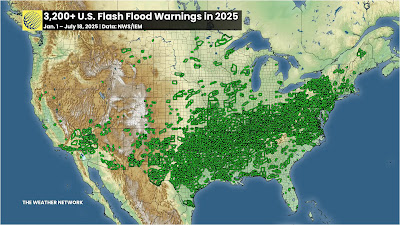
Each tiny green box in this map is one of the flash flood
warnings issued between January 1 and July 18 this year
Source: The Weather Network. 
Inland states, cities and towns are not as prepared for the extremes like the newly ferocious floods that now strike places like they did in western North Carolina during last September's Hurricane Helene, and the tragic floods in the Texas Hill Country in early July. 

We keep hearing these floods described as one in 1000 year events. That means there's just a 0.1 percent chance of that event happening in that place in any given year. 

However as CNN explains:

"But climate change is losing the dice in favor of extreme precipitation. 

'When we talk about e.g. 1,000 year events, we're talking about the likelihood of these events in the absence of human-caused warming (i.e, how often we would expect the from natural variability alone),' said climate scientist Michael Mann of the University of Pennsylvania. 'These events are of course much more frequent 'because' of human-caused warming,' he said in an email."

As the Washington Post points out, for every 1 degree Celsius (1.8 degrees Fahrenheit) of warming air is capable of holding 7 percent more moisture. 

That moisture has to go somewhere. Hence the floods,  Some climate scientists also increasingly think weather patterns can get "stuck" in place more often, due to climate change. 

CNN continues:

"A recent study Mann worked on found such weather patterns have tripled in incidence since the mid-with century during the summer months. The problem is these patterns are 'not necessarily well captured in climate models' he said. This increases uncertainty about future projections for extreme weather events."

WHAT TO DO?

This trend toward more and worse floods will only continue. 

Sure, some summers in the United States and elsewhere will be drier than this one.  A few future summers will feature punishing droughts. After all, depending on the prevailing weather patterns of the season, winds could come from dry sources like central Mexico, or the Desert Southwest. 

But overall, we are now permanent stuck in a world that floods more easily and more dramatically than ever before. And it will get worse.

We are not ready for that. 

As the Washington Post quoted:

"'Any given community can't know if it's going to be the next one that's going to  have a flood that is orders of magnitude larger than the largest flood they've known,' said disaster researcher Rachel Hogan Carr, who co-chairs a World Meteorological Organization project aimed at improving flood warnings. 'But we must all know now that we should be prepared.'"

One reason so many people died in Hurricane Helene - and the mega flood earlier this month in Texas, is that people couldn't imagine things would get that bad. And plans were not necessarily in place to deal with it. 

In western North Carolina, perhaps not enough people fled from the impending danger from the floods, as the Washington Post reported:

 "Though the National Weather Service correctly predicted that the flooding would be deadly, the warnings from local authorities were not forceful or specific enough to sway residents who never imagined a hurricane could hurt them so far from the sea."

The same problem came with the Texas flood. Meteorologists accurate predicted the torrential rains that brought the floods. But authorities didn't order evacuations in many of the hardest hit areas. And warnings didn't reach many until it was too late to flee. Some of those people died. 

The lesson: Detailed disaster plans need to be established, ones that take the warnings from the National Weather Service and get them to the people who need to hear them. And somehow, the public needs to be trained to heed these flash flood warnings, and know how to get out of the way quickly. 

I'm not optimistic we can get there anytime soon, given the Trump-era cutbacks and the National Weather Service and their laissez-faire approach to emergency management.   

THE AFTERMATH

For flood survivors, the mega floods leave incredible destruction that threaten the very existence of their communities.  

An example is Ellicott City, Maryland, a charming, old small city not far west of Baltimore, was devastated three times within a decade, first in 2011, then an even worse flash flood in 2016 and then the worst of them all in 2018,  

Once again, it rained hard in Ellicott City a couple weeks ago and the dreaded flash flood warnings were issued. Nearly 3.5 inches of rain pounded the community within three hours on July 13. Another 1.5 inches fell in less than an hour the next day. That's close to the amount of rain that devastated Ellicott City in 2018.

"When it rains like it did Monday and Sunday, a wave of fear comes over business owner Cindi Ryland told CBS Baltimore. 'What we go through here every time it rains, we all just hold our breath,' Ryland said. 'It's frightening, but we're here and we're resilient."

This time, the water caused only minor damage,  But only because of some painful and very expensive redesigns and rethinking in Ellicott City. 

Per CBS Baltimore: 

"The projects include five retention ponds, two of which are complete, and two water conveyance project, Those include a series of culverts under Maryland Avenue and the North Tunnel project

The third retention pond is expected to be up and running in the fall. The North Tunnel is expected to be complete by fall 2027 while the culvert are in their final design stage"

The changes already completed were apparently enough to prevent another catastrophic flood in Ellicott City this time.  

But the project came at a big financial and community loss, Ellicott City had to tear down four historic buildings. The cost is estimated at $130 million, which includes a $75 million loan from the federal Environmental Protection Agency and $20 million from the state of Maryland. 

This is just one community. Imagine how much it will cost to project dozens, or hundreds, or thousands of communities from the new flood regime we're under. 

There's echoes of Ellicott City parallels Vermont communities like Barre, hit hard by floods in both 2023 and 2024.

The 2023 flood damage 350 properties were damaged. Barre, among other things has been looking at buyouts.. Sixty-seven property owners jumped at the chance to sell their flood-prone properties. 

Those properties would be razed, and the remaining land would just become open floodplain. Maybe parks or farmland, but no houses, no commercial structures. 

This type of buyout, though, is painful to the communities involved. With each demolished house, Barre would lose some of its tax base. Right when the cash-strapped city is also trying to pay for flood recovery. 

It got so bad, that Barre rejected some applications for the buyouts. Barre's city manager said approving all the buyouts would  have gotten rid of roughly $280,000 in property tax revenue. 

Barre isn't a rich little city either, About a quarter of the residents are at or below the poverty level. Plus Barre needs more housing, not less. At last report, the city rejected 40 of the 27 buyout requests. 

Now imagine how many Barres are out there. It's challenging!  

NO TRUMP HELP

To make things worse, the Trump administration is clawing back money set for these flood mitigation projects. Basically, since Trump doesn't think climate change exists, there's no need for the funding. 

It also interesting that Trump signed this into law back in 2018 and now he's dumping the idea 

Virtually all climate scientists disagree with Trump, but the narcissist in chief insists he's always right, so there you go.

Anyway, 20 states, including Vermont, are suing the Trump administration's  decision a couple  months back to end a multi-billion dollar federal program that helps communities gird themselves against future floods as Vermont Public reports.   

The program is called Building Resilient Infrastructure and Communities (BRIC). It covered as much as 90 percent of the cost of things like restoring floodplains, expanding and improving culverts and bridges and protecting wastewater and drinking water treatment plants  

 It looks like Vermont was supposed to get about $5 million in funding through BRIC this year to fund 36 projects around the state.  

So, the floods are going to continue and get worse, and the tools are being taken away from us to deal with that wet future.

Everything is backwards these days.